개방형 공간 정보 컨소시엄(Open Geospatial Consortium, OGC)은 1994년에 기원한 국제 표준화 기구입니다. OGC에서 전 세계 500곳 이상의 상업, 정부, 비영리, 연구 단체들이 지리 공간적 콘텐츠와 서비스, 센서 웹, 사물 인터넷, GIS 데이터 처리, 데이터 공유를 위한 개방형 표준의 개발 및 구현을 장려하는 콘센서스 프로세스에서 서로 협업하고 있습니다.
| 기관명 | 개방형 공간 정보 컨소시엄 (OGC), 비영리기관 |
| 총회 | 4회/년 (2회 미국, 1회 유럽, 1회 아시아/태평양) |
| 설립목적 | - 첨단 기술을 GIS 분야에 활용하기 위해 민간산업체를 중심으로 설립 - 개방적으로 상호 운용할 수 있는 컴포넌트 개발 |
| 참여기관 | - Google, Microsoft, Oracle, ESRI 등 500여개의 산업계 컨소시엄 - 정부기관, 연구소, 대학 등 참여 - 국내: 공간정보연구원, 국토해양부, ETRI, 삼성 SDS, 현대오토에버, 건국대 등 - 회원(membership) 종류: Associate, Technical, Principal, Strategic |
역사 (History)
OGC 이전의 단체 OGF(Open GRASS Foundation)는 1992년에 시작했습니다.
1994년부터 2004년까지 이 단체는 Open GIS Consortium이라는 이름을 사용하기도 했습니다.
OGC 웹사이트는 OGC의 자세한 역사를 제공합니다.
표준 (Standards)
대부분의 OGC 표준은 지리적 기능(features)을 나타내는 기본 데이터 모델을 설명하는 추상 사양(Abstract Specification)이라고 하는 일련의 문서에 저장된 일반화된 구조에 의존합니다. Abstract Specification 회원들은 GIS를 포함하여 상호운용 가능한 위치 및 지리 공간 기술에 대한 특정 요구사항을 충족하기 위해 점점 더 많은 사양 혹은 표준들을 개발했고 계속 진행하고 있습니다.
OGC 표준 기준은 다음을 포함하여 30여개 이상의 표준으로 구성됩니다.
- 3D Tiles – Designed for streaming and rendering massive 3D geospatial content such as Photogrammetry, 3D Buildings, BIM/CAD, Instanced Features, and Point Clouds.
- CSW – Catalog Service for the Web: access to catalog information
- GML – Geography Markup Language: XML-format for geographical information
- GeoPackage – An open, standards-based, platform-independent, portable, self-describing, compact format for transferring geospatial information
- GeoSPARQL – Geographic SPARQL Protocol and RDF Query Language: representation and querying of geospatial data for the Semantic Web
- GeoXACML – Geospatial eXtensible Access Control Markup Language
- KML – Keyhole Markup Language: XML-based language schema for expressing geographic annotation and visualization on existing (or future) Web-based, two-dimensional maps and three-dimensional Earth browsers
- Observations and Measurements
- OGC Reference Model – a complete set of reference models
- OLS – Open Location Service (OpenLS)
- OGC Web Services Context Document defines the application state of an OGC Integrated Client
- OWS – OGC Web Service Common
- SOS – Sensor Observation Service
- SPS – Sensor Planning Service
- SensorML – Sensor Model Language
- SensorThings API - an open and unified framework to interconnect IoT devices, data, and applications over the Web. Currently a candidate standard waiting for votes.
- SFS – Simple Features – SQL
- SLD - Styled Layer Descriptor
- SRID, an identification for spatial coordinate systems
- WaterML – Information model for the representation of hydrological observation data
- WCS – Web Coverage Service: provides access, subsetting, and processing on coverage objects
- WCPS – Web Coverage Processing Service: provides a raster query language for ad-hoc processing and filtering on raster coverages
- WFS – Web Feature Service: for retrieving or altering feature descriptions
- WMS – Web Map Service: provides map images
- WMTS – Web Map Tile Service: provides map image tiles
- WPS – Web Processing Service: remote processing service
- WTS – Web Terrain Service (WTS)

표준 설계는 원래 웹 기반 시스템의 메시지 기반 상호 작용을 위해 HTTP 웹 서비스 패러다임에 구축되었지만 그 사이에 SOAP 프로토콜 및 WSDL 바인딩에 대한 공통 접근 방식으로 확장되었습니다. OGC SensorThings API와 같은 REST 웹 서비스를 정의하는 데 많은 진전이 있었습니다.
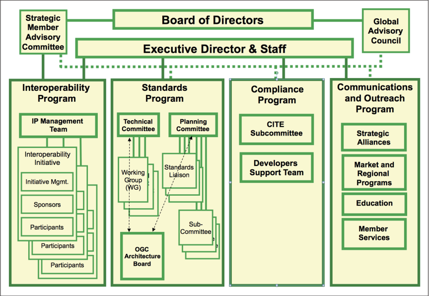
조직 구조 (Organization Structure)
OGC는 세 개의 운영 단위로 구성됩니다:
- 표준 프로그램(Standards Program)
- 상호운용성 프로그램(Interoperability Program)
- 적합성 프로그램(Compliance Program)
- 전파 및 커뮤니티 채택(Outreach and Community Adoption)
협업 (Collaboration)
OGC는 ISO/TC 211(Geographic Information/Geomatics)과 밀접한 관계가 있습니다. 이 위원회에서 개발 중인 ISO 19100 시리즈의 볼륨들은 점진적으로 OGC 추상형 사양을 대체하고 있습니다. 또, OGC 표준인 웹 맵 서비스, GML, 웹 피처 서비스(Web Feature Service), Observations and Measurements, 심플 피처 액세스(Simple Features Access)는 ISO 표준이 되었습니다.
참고사이트
'GIS > GIS Terminology' 카테고리의 다른 글
| 지오코딩(Geocoding) (0) | 2024.05.11 |
|---|---|
| 원주율(Pi) (0) | 2023.04.16 |
| WKT(Well-Known Text) (0) | 2023.04.12 |
| 지구타원체, 편평률(flatterning)과 이심률(eccentricity) (0) | 2023.04.10 |
| 데카르트 좌표계 (Cartesian Coordinate System) (1) | 2023.04.08 |


